McConnell also notes that Inmarsat – the British generator of phony 370 tracking data – took a 19-per-cent stake in SkyWave in July 2009 just before Canada's SkyWave company launched its GLONASS / GPS product for the Russian market and thereby gave Serco air traffic controllers the opportunity to fly a Sukhoi Superjet 100 into the side of an Indonesian volcano on May 9. 2012 and land MH 370 on Diego Garcia under the watchful eyes of Serco/G4S security guards.
Prequel 1: #1978: Marine Links Serco's 370 Red Switch Boeing to SkyWave GPS Blue Force Hacking

737NG Flight Simulator - No.4 for Take Off WMKK
MISSING MALAYSIA FLIGHT MH370 - CNN Tried To Rent An Actual Boeing 777 Airplane for its Coverage
Could Malaysian Airlines Flight MH370 Land at Diego Garcia?
Did Inmarsat data point Flight 370 searchers in wrong direction? Back to discuss the validity of the Inmarsat data that originally pointed Flight 370 searchers to the southern Indian Ocean are CNN aviation analysts Miles O'Brien and Arthur Rosenberg, and CNN safety analyst David Soucie.
"In 2005 Apax Partners and Permira bought shares in the company [Inmarsat]. The company was also first listed on the London Stock Exchange in that year.[6] In March 2008 it was disclosed that U.S. hedge fund Harbinger Capital owned 28% of the company.[7] In July 2009, Inmarsat completed the acquisition of a 19-per-cent stake in SkyWave Mobile Communications Inc., a provider of Inmarsat D+/IsatM2M network services which in turn purchased the GlobalWave business from TransCore.[8]
On 15 April 2009, Inmarsat completed the acquisition of satellite communications provider Stratos Global Corporation (Stratos) ..
Inmarsat's analysis of satellite data in March 2014 showed that Malaysia Airlines Flight 370 flew south from its last known position north of its originating airport in Kuala Lumpur -- rather than continuing to fly north, as it was supposed to. That analysis was the key factor in causing the search area for the missing plane to be shifted from its last known position to the southern Indian Ocean, thus significantly assisting in the search [You don’t say!]. [11]"
"SkyWave Mobile Communications ("SkyWave") is a global provider of satellite and satellite-cellular devices in the Machine-to-Machine (M2M) market. SkyWave's products allow customers to track, monitor and control industrial vehicles, vessels and industrial equipment. Applications include tracking the location of vehicle fleets, monitoring data from oil & gas flow meters and turning on and off pumps. More examples of applications can be found in the Market section.
SkyWave’s satellite products communicate via Inmarsat's global satellite service. [1] .[2] The main industries their products are used in are the transportation, maritime, mining, oil & gas, heavy equipment, emergency management, water monitoring, and utilities sectors.
History[edit]
SkyWave Mobile Communications was founded in Ottawa, Canada in 1997. In its initial stages, SkyWave relied on the research and technical expertise provided by the Communications Research Centre Canada (CRC) and local government funding services to develop the first product.[3]
Some examples of SkyWave products in use include government vehicles in USA,[4] tuna buoys in the Pacific, truck tracking in the jungles of Brazil, the oil & gas industry in North America, and drinking water control in the UK.[5] In addition, SkyWave’s satellite terminals have been used to track races such as Rhino Charge 2011,[6] the Dubai-Muscat Offshore Sailing Race in 2008[7] and the China Sea Race from Hong Kong to Subic Bay in 2006.[8]
On April 1, 2009, Inmarsat acquired a 19% stake in SkyWave Mobile Communications to expand presence in the SLDR (Satellite Low Data Rate) market. SkyWave used the funds to acquire GlobalWave and double its size.[9][10] The SLDR market is estimated at $600m and is expected to grow.[11]
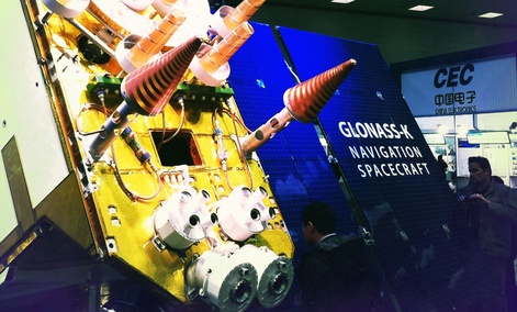
In December 2009, SkyWave launched a GLONASS-compatible product for the Russian market. The DMR-800L with GLONASS/GPS can use either or both of the navigation systems to determine location.[12]..
SkyWave’s satellite products communicate via Inmarsat's global satellite service. [1] .[2] The main industries their products are used in are the transportation, maritime, mining, oil & gas, heavy equipment, emergency management, water monitoring, and utilities sectors.
History[edit]
SkyWave Mobile Communications was founded in Ottawa, Canada in 1997. In its initial stages, SkyWave relied on the research and technical expertise provided by the Communications Research Centre Canada (CRC) and local government funding services to develop the first product.[3]
Some examples of SkyWave products in use include government vehicles in USA,[4] tuna buoys in the Pacific, truck tracking in the jungles of Brazil, the oil & gas industry in North America, and drinking water control in the UK.[5] In addition, SkyWave’s satellite terminals have been used to track races such as Rhino Charge 2011,[6] the Dubai-Muscat Offshore Sailing Race in 2008[7] and the China Sea Race from Hong Kong to Subic Bay in 2006.[8]
On April 1, 2009, Inmarsat acquired a 19% stake in SkyWave Mobile Communications to expand presence in the SLDR (Satellite Low Data Rate) market. SkyWave used the funds to acquire GlobalWave and double its size.[9][10] The SLDR market is estimated at $600m and is expected to grow.[11]
In December 2009, SkyWave launched a GLONASS-compatible product for the Russian market. The DMR-800L with GLONASS/GPS can use either or both of the navigation systems to determine location.[12]..
SkyWave sells terminals to Solution Providers who put satellite communications products and services into industry-specific applications for their customers. The following are some of the main uses for this technology:
Transportation Applications:[1]
Vehicle tracking and monitoring, fleet management
Security and anti-theft monitoring
Heavy equipment security and management[15]
Trailer and container tracking, rail car tracking
Mining Applications:
Heavy equipment and machine tracking[16]
Remote installation sensor monitoring[17]
Water management
Maritime applications:[1]
Vessel equipment, environment, security monitoring
Commercial fishing boat and leisure marine tracking[21]
Merchant marine monitoring
Buoy sensor monitoring and tracking
Oil & Gas Applications:[22]
Cathodic protection
SCADA equipment monitoring and management
Fluids monitoring
Electric power valves monitoring and control
Defence and Security Applications:[22]
Personnel tracking
Perimeter control
Homeland and border security
Blue Force Tracking, protection, monitoring, and security
Utilities Applications:
Water quality and quantity monitoring
Water regulation and control
Real-time analysis and monitoring
Emergency response alerts
Metering[25]
Emergency Management
Fleet tracking
Siren warning system[26]"
"A coded modulation design for the INMARSAT geostationary GLONASS augmentation
A coded modulation scheme is proposed to carry out the Global Navigation Satellite System (GLONASS) geostationary augmentation which includes both integrity and navigation functions over the next generation International Maritime Satellite Organization (INMARSAT) satellites. A baseline coded modulation scheme for the GLONASS augmentation broadcast proposes a forward error correction code over a differential phase shift keying (DPSK) modulation. The use of a concatenated code over the same signaling is considered. The proposed coded modulation design is more powerful and robust, yet not overly more complex in system implementation than the baseline scheme. Performance results of concatenated codes over a DPSK signaling used in the design are presented. The sensitivity analysis methodology in selecting the coded modulation scheme is also discussed
Published in:
Date of Conference:
4-7 Nov 1991
Page(s):
321 - 325 vol.1
Meeting Date :
04 Nov 1991-07 Nov 1991
Print ISBN:
0-87942-691-8
INSPEC Accession Number:
4269315”
“On 9 May 2012 a Russian Sukhoi Superjet 100 airliner, on a demonstration flight with 37 passengers and eight Russian crew members on board, crashed after it took off from the Halim Perdanakusuma Airport in Jakarta, Indonesia. About twenty minutes after the take-off, the crew requested permission to descend to 1,800 metres (5,900 ft), which was granted. This was the last contact that Air Traffic Control had with the aircraft, which was then about 139 kilometres (75 nmi) south of Jakarta, in the vicinity of the 2,211-metre-high (7,254 ft) Mount Salak, a mountain higher than the requested flight level.[129] After an extensive search, rescuers concluded, based on the widespread debris field on the side of a ridge, that the aircraft directly struck the rocky side of Mount Salak and there was "no chance of survival".[130][131]
An official inquiry into the crash found that the plane's automatic collision avoidance system was working, but had been ignored by the pilot, who was possibly distracted by his conversation with a potential customer for the aircraft.[132][133]”
McConnell will start work on a simulation video to show Abel Danger's theory of how Serco could have authorized the March 8 hijack of MH Flight 370 using SkyWave GPS devices for take-off from Kuala Lumpur airport followed by a GLONASS Cat IIIc landing with the Boeing 777-200 autopilot synchronized to the Inmarsat satellite hovering above Diego Garcia, British Indian Ocean Territory.
Yours sincerely,
Field McConnell, United States Naval Academy, 1971; Forensic Economist; 30 year airline and 22 year military pilot; 23,000 hours of safety; Tel: 715 307 8222
David Hawkins Tel: 604 542-0891 Forensic Economist; former leader of oil-well blowA-out teams; now sponsors Grand Juries in CSI Crime and Safety Investigation
Field, I look forward to your simulation video demonstrating how Serco could have orchestrated the hijacking of MH370. When can we be expecting it's completion?
ReplyDelete