McConnell notes that Serco’s Red Switch Network is used by the National Command Authority guests who fly in Boeing aircraft or stay at Starwood Hotels giving their hit teams opportunities to hack Blue Force assets and switch SkyWave GPS and GLONASS signals for contract hits.
McConnell also notes that Inmarsat – the British generator of phony 370 tracking data – took a 19-per-cent stake in SkyWave in July 2009 just before SkyWave launched its GLONASS / GPS product for the Russian market which would have allowed Serco hit teams to hack and track the Sukhoi Superjet 100 which crashed into the side of a volcano in Indonesia on 9 May 2012.
Prequel 1:
#1977: Marine Links Churchill’s Red Switch Grandsons to Inmarsat Hangout Track, Zaharie SkyWave Hack
Memorial Day: Field McConnell’s speech on Treason:

Stealth BUAP MH370 · War Game Exercises · Serco Flash Override of Cope Tiger Search & Rescue
The Blue Force Tracker System
Inmarsat finally release MH370 satellite data released after months of waiting
'Missing Malaysian jet's flight route was re-programmed for diversion'


SkyWave and Inmarsat Launch IsatData Pro
Inside Inmarsat control room that tracked MH370 - BBC News
“SkyWave Mobile Communications (“SkyWave”) is a global provider of satellite and satellite-cellular devices in the Machine-to-Machine (M2M) market. SkyWave's products allow customers to track, monitor and control industrial vehicles, vessels and industrial equipment. Applications include tracking the location of vehicle fleets, monitoring data from oil & gas flow meters and turning on and off pumps. More examples of applications can be found in the Market section.
SkyWave’s satellite products communicate via Inmarsat's global satellite service. [1] .[2] The main industries their products are used in are the transportation, maritime, mining, oil & gas, heavy equipment, emergency management, water monitoring, and utilities sectors.
History[edit]
SkyWave Mobile Communications was founded in Ottawa, Canada in 1997. In its initial stages, SkyWave relied on the research and technical expertise provided by the Communications Research Centre Canada (CRC) and local government funding services to develop the first product.[3]
Some examples of SkyWave products in use include government vehicles in USA,[4] tuna buoys in the Pacific, truck tracking in the jungles of Brazil, the oil & gas industry in North America, and drinking water control in the UK.[5] In addition, SkyWave’s satellite terminals have been used to track races such as Rhino Charge 2011,[6] the Dubai-Muscat Offshore Sailing Race in 2008[7] and the China Sea Race from Hong Kong to Subic Bay in 2006.[8]
On April 1, 2009, Inmarsat acquired a 19% stake in SkyWave Mobile Communications to expand presence in the SLDR (Satellite Low Data Rate) market. SkyWave used the funds to acquire GlobalWave and double its size.[9][10] The SLDR market is estimated at $600m and is expected to grow.[11]
In December 2009, SkyWave launched a GLONASS-compatible product for the Russian market. The DMR-800L with GLONASS/GPS can use either or both of the navigation systems to determine location.[12]..
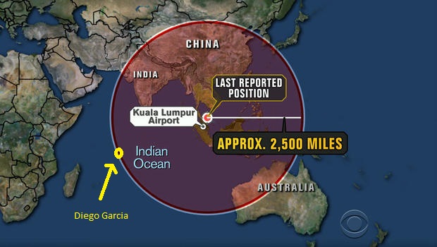
McConnell will now start work on a simulation video to show Abel Danger’s theory of how a Red Switch hack of the Boeing Uninterruptible Autopilot and SkyWave Blue Force assets took Captain Zaharie’s MH Flight 370 to a CAT III c landing on Diego Garcia, British Indian Ocean Territory, on March 8.
Yours sincerely,
Field McConnell, United States Naval Academy, 1971; Forensic Economist; 30 year airline and 22 year military pilot; 23,000 hours of safety; Tel: 715 307 8222
David Hawkins Tel: 604 542-0891 Forensic Economist; former leader of oil-well blowA-out teams; now sponsors Grand Juries in CSI Crime and Safety Investigation
Inmarsat finally release MH370 satellite data released after months of waiting
'Missing Malaysian jet's flight route was re-programmed for diversion'


SkyWave and Inmarsat Launch IsatData Pro
Inside Inmarsat control room that tracked MH370 - BBC News
“In 2005 Apax Partners and Permira bought shares in the company [Inmarsat]. The company was also first listed on the London Stock Exchange in that year.[6] In March 2008 it was disclosed that U.S. hedge fund Harbinger Capital owned 28% of the company.[7] In July 2009, Inmarsat completed the acquisition of a 19-per-cent stake in SkyWave Mobile Communications Inc., a provider of Inmarsat D+/IsatM2M network services which in turn purchased the GlobalWave business from TransCore.[8] On 15 April 2009, Inmarsat completed the acquisition of satellite communications provider Stratos Global Corporation (Stratos) ..
Inmarsat's analysis of satellite data in March 2014 showed that Malaysia Airlines Flight 370 flew south from its last known position north of its originating airport in Kuala Lumpur -- rather than continuing to fly north, as it was supposed to. That analysis was the key factor in causing the search area for the missing plane to be shifted from its last known position to the southern Indian Ocean, thus significantly assisting in the search [You don’t say!].[11]”
“Topic: Security
MoD unfazed by satellite phone encryption crack
Summary: The Ministry of Defence has said that the cracking of two commonly-used satellite phone encryption algorithms will not affect military operations
By Tom Espiner | February 8, 2012 -- 14:50 GMT (06:50 PST)
The Ministry of Defence has said a satellite phone encryption crack by researchers will not affect UK military use of satellite phones.
The crack of the A5-GMR-1 and A5-GMR-2 encryption algorithms will not affect military operations, the Ministry of Defence (MoD) told ZDNet UK on Wednesday.
…
MI5 and the Secret Intelligence Service (SIS) declined to comment on use of satellite phones by the intelligence services. "We don't comment on operational security cases," a spokeswoman for the intelligence services told ZDNet UK on Tuesday.
Satellite phones are used by organisations operating outside the coverage range of mobile phones — shipping, oil and gas exploration, and military use for example. A satellite phone establishes a radio link to a satellite, which transmits the incoming call to a ground station. The call is then passed to a telephone network.
The A5-GMR-1 and A5-GMR-2 encryption algorithms are embedded in two commonly-used satellite phone standards — GMR-1 and GMR-2.
German researchers claimed to have cracked the A5-GMR-1 and A5-GMR-2 encryption algorithms in two papers and an FAQ publishedon Tuesday. Researchers from Ruhr-University Bochum used open-source software and techniques associated with cracking GSM encryption to find "serious weaknesses" in the algorithms, they claimed.
The researchers obtained the algorithms by analysing software running on Thuraya SO-2510 and Inmarsat IsatPhone Pro phones. The Thuraya phone used the GMR-1 standard, according to the researchers…
For the Inmarsat phone, the researchers said they had found a theoretical attack that they had not implemented. The researchers said that a known-plaintext attack — where an attacker knows or guesses at parts of the encrypted message — would work against A5-GMR-2 and the proprietary Inmarsat algorithm GMR-2+.
Inmarsat said on Wednesday that the theoretical attack detailed by the researchers was "a little bit of a stretch"….
Customers that were concerned about protecting conversations using Inmarsat phones could add an additional layer of encryption, said McGaughlin. Inmarsat does not currently provide that encryption layer itself, but is considering offering military-grade encryption, McGaughlin added."
Topic: Security”
“The Mount Salak Sukhoi Superjet 100 (SSJ-100) crash occurred on 9 May 2012 when an SSJ-100 aircraft crashed on a demonstration flight operating from Halim Perdanakusuma Airport, Jakarta, Indonesia.[1] On 10 May, the wreckage of the Sukhoi Superjet was spotted on a cliff in Mount Salak, a volcano in the province of West Java. Due to the widespread debris field where the aircraft hit the mountain, rescuers concluded that the aircraft directly impacted the rocky side of the mountain and that there was "no chance of survival".[2][3] On 12 May 2012, it was reported that the remains of several victims' bodies had been recovered and airlifted to Halim Airport and then taken to the National Police Hospital for identification.[4]
The final report, released 18 December 2012, indicated that the accident was caused by crew members ignoring terrain warnings that they had incorrectly attributed to a database problem. The crew had turned off the terrain warning system and were unaware that they were operating in close proximity to mountains. The crew, including the captain, were engaging in conversation with potential customers as the aircraft impacted the ground.[5]”
“SkyWave Mobile Communications (“SkyWave”) is a global provider of satellite and satellite-cellular devices in the Machine-to-Machine (M2M) market. SkyWave's products allow customers to track, monitor and control industrial vehicles, vessels and industrial equipment. Applications include tracking the location of vehicle fleets, monitoring data from oil & gas flow meters and turning on and off pumps. More examples of applications can be found in the Market section.
SkyWave’s satellite products communicate via Inmarsat's global satellite service. [1] .[2] The main industries their products are used in are the transportation, maritime, mining, oil & gas, heavy equipment, emergency management, water monitoring, and utilities sectors.
History[edit]
SkyWave Mobile Communications was founded in Ottawa, Canada in 1997. In its initial stages, SkyWave relied on the research and technical expertise provided by the Communications Research Centre Canada (CRC) and local government funding services to develop the first product.[3]
Some examples of SkyWave products in use include government vehicles in USA,[4] tuna buoys in the Pacific, truck tracking in the jungles of Brazil, the oil & gas industry in North America, and drinking water control in the UK.[5] In addition, SkyWave’s satellite terminals have been used to track races such as Rhino Charge 2011,[6] the Dubai-Muscat Offshore Sailing Race in 2008[7] and the China Sea Race from Hong Kong to Subic Bay in 2006.[8]
On April 1, 2009, Inmarsat acquired a 19% stake in SkyWave Mobile Communications to expand presence in the SLDR (Satellite Low Data Rate) market. SkyWave used the funds to acquire GlobalWave and double its size.[9][10] The SLDR market is estimated at $600m and is expected to grow.[11]
In December 2009, SkyWave launched a GLONASS-compatible product for the Russian market. The DMR-800L with GLONASS/GPS can use either or both of the navigation systems to determine location.[12]..
SkyWave sells terminals to Solution Providers who put satellite communications products and services into industry-specific applications for their customers. The following are some of the main uses for this technology:
Transportation Applications:[1]
Vehicle tracking and monitoring, fleet management
Security and anti-theft monitoring
Heavy equipment security and management[15]
Trailer and container tracking, rail car tracking
Mining Applications:
Heavy equipment and machine tracking[16]
Remote installation sensor monitoring[17]
Water management
Maritime applications:[1]
Vessel equipment, environment, security monitoring
Commercial fishing boat and leisure marine tracking[21]
Merchant marine monitoring
Buoy sensor monitoring and tracking
Oil & Gas Applications:[22]
Cathodic protection
SCADA equipment monitoring and management
Fluids monitoring
Electric power valves monitoring and control
Defence and Security Applications:[22]
Personnel tracking
Perimeter control
Homeland and border security
Blue Force Tracking, protection, monitoring, and security
Utilities Applications:
Water quality and quantity monitoring
Water regulation and control
Real-time analysis and monitoring
Emergency response alerts
Metering[25]
Emergency Management
Fleet tracking
Siren warning system[26]”
“Blue Force Tracking is a United States military term for a GPS-enabled system that provides military commanders and forces with location information about friendly (and despite its name, also hostile) military forces. In NATO military symbology, blue typically denotes friendly forces. The system provides a common picture of the location of friendly forces and therefore is referred to as the "Blue Force" tracker.
Blue Force Tracking systems consist of a computer, used to display location information, a satellite terminal and satellite antenna, used to transmit location and other military data, a Global Positioning System receiver (to determine its own position), command-and-control software (to send and receive orders, and many other battlefield support functions), and mapping software, usually in the form of a geographic information system (GIS), that plots the BFT device on a map. The system displays the location of the host vehicle on the computer's terrain-map display, along with the locations of other platforms (friendly in blue, and enemy in red) in their respective locations. BFT can also be used to send and receive text and imagery messages, and Blue Force Tracking has a mechanism for reporting the locations of enemy forces and other battlefield conditions (for example, the location of mine fields, battlefield obstacles, bridges that are damaged, etc.).
Additional capability in some BFT devices is found in route planning tools. By inputting grid coordinates the BFT becomes both the map and compass for motorized units. With proximity warnings enabled the vehicle crew is made aware as they approach critical or turn points.
Adoption[edit]
Users of BFT systems include the United States Army, the United States Marines Corps, the United States Air Force, the United States Navy ground-based expeditionary forces (e.g., NSWC and NECC units), and the United Kingdom.
In 2008, work began on plans to reach the level of nearly 160,000 tracking systems in the US Army within a few years; the system prime contractor is the Northrop Grummancorporation of Los Angeles, California. The M1A1 Abrams's AIM refurbishment/upgrade program includes FBCB2 and Blue Force Tracking.[1]
In November 2010[2] the United States Army and the United States Marines Corps reached an agreement to standardize on a shared system, to be called "Joint Battle Command Platform", which will be derived from the Army's FBCB2 system that was used by the United States Army, the United States Marines Corps, and the British Army during heavy combat operations in Iraq in 2003.
An Army-specific Blue Force Tracking technology is Force XXI Battle Command Brigade and Below, or FBCB2. The system continually transmits locations over the FBCB2 network. It then monitors the location and progress of friendly (and enemy) forces, and sends those specific coordinates to a central location called the Army Tactical Operations Center. There the data are consolidated into a common operational picture, or COP, and sent to numerous destinations, such as the headquarters element, other in-theater forces, or back out to other military units for situational awareness. The system also allows users to input or update operational graphics (i.e. obstacles, engineer reconnaissance on the road, enemy forces). Once uploaded, it can either be sent to higher headquarters or "mailed" to other subscribers of that user's list, or other BFT users within the subscription system.[citation needed]
The BFT system, and the FBCB2 system of which it is a variant, have won numerous awards and accolades, including: recognition in 2001 as one of the five best-managed software programs in the entire U.S. Government[[3]), the 2003 Institute for Defense and Government Advancement’s award for most innovative U.S. Government program,[4] the 2003 Federal Computer Week Monticello Award (given in recognition of an information system that has a direct, meaningful impact on human lives), and the Battlespace Information 2005 “Best Program in Support of Coalition Operations".[5]”
Yours sincerely,
Field McConnell, United States Naval Academy, 1971; Forensic Economist; 30 year airline and 22 year military pilot; 23,000 hours of safety; Tel: 715 307 8222
David Hawkins Tel: 604 542-0891 Forensic Economist; former leader of oil-well blowA-out teams; now sponsors Grand Juries in CSI Crime and Safety Investigation
No comments:
Post a Comment
Note: Only a member of this blog may post a comment.