McConnell notes that Rupert Soames is the new CEO of Serco which is inter alia; the world’s largest air traffic controller; the operator of Boeing’s C4SI and Starwood Hotels’ Red Switch Network facilities and the operator of the NPL cesium clock which allows Inmarsat to hack and track mobile assets through SkyWave GPS one moment and SkyWave GLONASS the next.
McConnell notes that Nicholas Soames was the UK defense minister (1994-1997) under John Major and arranged with the Malaysian government to outsource ATC training to Serco, the UK company now under investigation for tagging prison-based hit teams before deployment abroad.
Prequel 1:
#1976: Marine Links 370 Overlay to Serco Canada’s Red Switch, SkyWave-Inmarsat Hack

Inmarsat finally release MH370 satellite data released after months of waiting
'Missing Malaysian jet's flight route was re-programmed for diversion'


SkyWave and Inmarsat Launch IsatData Pro
Inside Inmarsat control room that tracked MH370 - BBC News
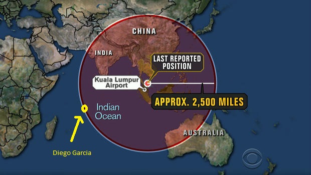
“Breaking!: MH370 INMARSAT Data Further Shows Plane Went To Diego Garcia
Tuesday, May 27, 2014 5:57
(Before It's News)
I haven’t had time to digest it all, but right off the bat I see a burst timing offset that suggest the plane was moving towards the satellite, because of the consistent increase of the offset timing. It’s either moving closer, or further, and since we know the satellite was located almost directly above Diego Garcia, and the plane left from Malaysia, the consistent increase in BTO means the plane was moving towards Diego Garcia, and not on the arc as originally suggested. (see page 40 of pdf. I have taken snippet below of pertinent info)
Still, it took me a while to find the link to the actual data, so I thought I’d share the actual pdf. http://www.dca.gov.my/mainpage/MH370%20Data%20Communication%20Logs.pdf
Edit to add: CNN is reporting that BTO is proving plane went away from satellite. Well, since the plane was picked up by INMARSAT before it veered off course, and the location of the final ping they are saying is on an arc that is exactly the same arc where the plane veered off course, how could this be. If that were the case, then BTO would decrease, then increase, only very slightly. And understand that they are purposely confusing the data with the offset, instead of time/distance, which is what the offset is ineffectively hiding.”
“MH 370 – Inmarsat Raw Data – All Thunder, No Rain
By Matthias Chang – Future Fast-Forward
29th May 2014
Inmarsat has finally released its “raw data” and in an interview with Richard Quest of CNN, expressed confidence that their conclusion that MH 370 crashed in the Southern Indian Ocean is correct. I will not waste time and will call a spade, a spade.
Inmarsat did not get it right. I repeat again, Inmarsat did not get it right. The plane did not crash in the Southern Indian ocean.
I now issue a global challenge to Inmarsat.
I dare Inmarsat to publish the “model” and all the calculations, projections etc. which support the “model” which they have created to justify their conclusions.
Additionally, I challenge Inmarsat to disclose the names of so-called “other organizations” and the experts that have created their separate “models” which corroborates, as alleged by Inmarsat, that their conclusions are correct.
I make this challenge because the Vice-President of Inmarsat, Mark Dickinson has stated in his interview with Richard Quest (a slimy presstitute) that, Because the model they created showing arcs and Doppler readings was rigorously tested, initially on other aircraft on the satellite at the same time, and then against previous flights by the same aircraft. With minor disagreements both the position and the Doppler reading of those aircraft was predicted accurately.
Other organizations created their own models, ran the comparisons and came to the same conclusions. It is essential to understand: This is not just Inmarsat's frolic.
Mathematicians, physicists, scientists and economists etc. create models to test their theories and often such models form the basis of their conclusions. The models and findings are published in peer-reviewed journals of their respective professions.
Full disclosure in such publications is a condition precedent that the author or creator of the “models” is prima facie confident that the models and the supporting data, projections, calculations, analysis would stand up to scrutiny. When such “models” are ground-breaking and sets new benchmarks, the creator of the models are often rewarded with the Nobel Prize in their respective discipline as a recognition of the pioneering work and excellence in research.
The Inmarsat “model” and data are not classified information, never were treated as classified information by US, UK, Australia, Malaysia or any other country. Yet it took Inmarsat more than two months to release the raw data and only after tremendous social pressure, especially from the families of the passengers and crew of MH 370.
This is disgusting and unacceptable by any standard of transparency.
To say now that they are releasing the raw data by reason of demonstrating transparency is an insult to the intelligence of the general public and the families of the passengers and crew of MH 370.
In the past I have defended the Malaysian government in the conduct of the SAR Mission. However, I cannot justify why the Malaysian government did not release Inmarsat data until now and only because of social pressure, when the data are not classified information and or that its release would jeopardized on-going investigations into any criminal aspects of the “disappearance of MH 370”.
Inmarsat data was in relation to the search for the plane and does not impact in any way any criminal investigations as it now turns out.
It is about time, that the Malaysian government be more open and stop the stonewalling by “vested interests” connected to the US and UK.
Enough is Enough.
End the charade of the wild goose chase in Southern Indian Ocean.
Inmarsat must answer to the challenge issued or stand accused of covering up the events leading to the “disappearance” of MH 370.”
“The company [Inmarsat] was originally founded in 1979 as the International Maritime Satellite Organization (Inmarsat), a not-for-profit international organization, set up at the behest of the International Maritime Organization (IMO), a UN body, for the purpose of establishing a satellite communications network for the maritime community.[2] Originally, the model was that of Intelsat, an international consortium which provided satellite communications among the member countries. The founding member of Intelsat, and the USA member, was Communications Satellite Corporation (COMSAT). Comsat also took the lead in the founding of Inmarsat. Inmarsat began trading in 1982.[3] From the beginning, the acronym "Inmarsat" was used. The intent was to create a self-financing body which would improve safety of life at sea.
The name was changed to "International Mobile Satellite Organization" when it began to provide services to aircraft and portable users, but the acronym "Inmarsat" was kept. When the organisation was converted into a private company in 1999, the business was split into two parts: The bulk of the organisation was converted into the commercial company, Inmarsat plc, and a small group became the regulatory body, IMSO.[4] Inmarsat was the first international satellite organization that was privatized.[5]
In 2005 Apax Partners and Permira bought shares in the company. The company was also first listed on the London Stock Exchange in that year.[6] In March 2008 it was disclosed that U.S. hedge fund Harbinger Capital owned 28% of the company.[7] In July 2009, Inmarsat completed the acquisition of a 19-per-cent stake in SkyWave Mobile Communications Inc., a provider of Inmarsat D+/IsatM2M network services which in turn purchased the GlobalWave business from TransCore.[8] On 15 April 2009, Inmarsat completed the acquisition of satellite communications provider Stratos Global Corporation (Stratos)
Inmarsat won the 2010 MacRobert Award for its Broadband Global Area Network (BGAN) service,[9] overcoming the three other shortlisted companies.[10]
Inmarsat's analysis of satellite data in March 2014 showed that Malaysia Airlines Flight 370 flew south from its last known position north of its originating airport in Kuala Lumpur -- rather than continuing to fly north, as it was supposed to. That analysis was the key factor in causing the search area for the missing plane to be shifted from its last known position to the southern Indian Ocean, thus significantly assisting in the search.[11]”
“SkyWave Mobile Communications (“SkyWave”) is a global provider of satellite and satellite-cellular devices in the Machine-to-Machine (M2M) market. SkyWave's products allow customers to track, monitor and control industrial vehicles, vessels and industrial equipment. Applications include tracking the location of vehicle fleets, monitoring data from oil & gas flow meters and turning on and off pumps. More examples of applications can be found in the Market section.
SkyWave’s satellite products communicate via Inmarsat's global satellite service. [1] .[2] The main industries their products are used in are the transportation, maritime, mining, oil & gas, heavy equipment, emergency management, water monitoring, and utilities sectors.
History[edit]
SkyWave Mobile Communications was founded in Ottawa, Canada in 1997. In its initial stages, SkyWave relied on the research and technical expertise provided by the Communications Research Centre Canada (CRC) and local government funding services to develop the first product.[3]
Some examples of SkyWave products in use include government vehicles in USA,[4] tuna buoys in the Pacific, truck tracking in the jungles of Brazil, the oil & gas industry in North America, and drinking water control in the UK.[5] In addition, SkyWave’s satellite terminals have been used to track races such as Rhino Charge 2011,[6] the Dubai-Muscat Offshore Sailing Race in 2008[7] and the China Sea Race from Hong Kong to Subic Bay in 2006.[8]
On April 1, 2009, Inmarsat acquired a 19% stake in SkyWave Mobile Communications to expand presence in the SLDR (Satellite Low Data Rate) market. SkyWave used the funds to acquire GlobalWave and double its size.[9][10] The SLDR market is estimated at $600m and is expected to grow.[11]
In December 2009, SkyWave launched a GLONASS-compatible product for the Russian market. The DMR-800L with GLONASS/GPS can use either or both of the navigation systems to determine location.[12]
In August 2011, SkyWave launched IsatData Pro, a new low data rate service for managing and communicating with remote assets around the world.[13] IsatData Pro offers a significant increase in payload capacity compared to other satellite-based M2M services in the market, delivering up to 10,000 bytes to the device and up to 6,400 bytes from the device. Other global M2M satellite services currently available offer data connectivity at between 270 and 340 bytes. By delivering up to 37 times more data, IsatData Pro can meet the increasing demand for richer information in M2M applications, and allows businesses to share more data across diverse operations, via emails, electronic forms and workflow information. Applications include vehicle telemetry information, text-messaging remote workers, maintaining up-to-date driver logs, and the remote management and control of fixed assets.
In 2012, SkyWave introduced IP SCADA service to work with its IDP series terminals for remote sites. IP SCADA allows IP-based point-to-point satellite communication connections between small remote sites and SCADA systems where other communications are unavailable, unreliable, or cost prohibitive.[14]
Today, SkyWave is located in Ottawa’s technology district, west of the town of Kanata, Ontario and employs over 180 people. SkyWave has designed, manufactured and shipped more than 600,000 satellite terminals to customers in the transportation, maritime, oil and gas, heavy equipment, utilities and government sectors worldwide.[1][9]
Markets[edit]
SkyWave sells terminals to Solution Providers who put satellite communications products and services into industry-specific applications for their customers. The following are some of the main uses for this technology:
Transportation Applications:[1]
Vehicle tracking and monitoring, fleet management
Security and anti-theft monitoring
Heavy equipment security and management[15]
Trailer and container tracking, rail car tracking
Cold Chain Management
Mining Applications:
Heavy equipment and machine tracking[16]
Remote installation sensor monitoring[17]
Water management
Maritime applications:[1]
Long Range Identification and Tracking (LRIT)[18][19]
Ship Security Alerting System (SSAS)
Vessel monitoring system (VMS)[20]
Vessel equipment, environment, security monitoring
Commercial fishing boat and leisure marine tracking[21]
Merchant marine monitoring
Buoy sensor monitoring and tracking
Oil & Gas Applications:[22]
Oil & gas pipeline and critical parameters monitoring and control [23] [24] Cathodic protection
SCADA equipment monitoring and management
Fluids monitoring
Electric power valves monitoring and control Environmental monitoring
Defence and Security Applications:[22]
Personnel tracking
Perimeter control
Homeland and border security
Blue Force Tracking, protection, monitoring, and security
Utilities Applications:
Water quality and quantity monitoring
Water regulation and control
Real-time analysis and monitoring
Emergency response alerts
Metering[25]
Emergency Management
Fleet tracking Siren warning system[26]
Products[edit]
The following are the satellite terminals manufactured by SkyWave Mobile Communications:[22]
IsatData Pro
IDP 800 Series- The IDP 800 is a low profile terminal ideal for tracking trailers, containers, vehicles and vessels. It can be powered by non-rechargeable batteries, rechargeable batteries, or vehicle power.
IDP 700 Series- The IDP-780 terminal is equipped with both IsatData Pro satellite and cellular modems so it can use the lowest cost communication network depending on availability and quality of service.[27]
IDP600 Series- The IDP 600 Series terminals use the two-way Inmarsat IsatData Pro satellite service for remotely managing fixed and mobile assets anywhere in the world. Models include one for low-elevation and maritime applications as well as applications that require Class 1 Division 2 certification.
IDP100 Series- The IDP 100 Series modems are designed to be integrated into larger systems and use the two-way Inmarsat IsatData Pro satellite service.
IsatM2M
SureLinx 8100/8100c- A dual-mode satellite/GPRS transceiver that switches between cellular (GPRS) frequencies and IsatM2M satellite service when cellular service is not available. The SureLinx 8100c has an on-board computer designed specifically for vehicle telemetry applications.
DMR-800D - A satellite-only transceiver with two-way communication capabilities and low-power mode that allows use in remote unmanned locations.
DMR-800L - This transceiver is designed with a low look angle to be used in harsh conditions and marine environments.
DMR-800 OEM- A DMR-800 transceiver that comes unpackaged, allowing for customization and addition of sensors according to application needs.
DMR-800D C1D2 - A Class 1 Division 2 certified satellite transceiver that allows monitoring of assets, processes and environments in hazardous locations. The product includes a RS-485 serial interface for connection to SCADA devices, Modbus protocol interfaces for implementing reporting and telemetry capabilities of remote equipment and discrete input/output feeds for monitoring and control of local devices not using Modbus.
DMR-800LRIT [18]- The DMR-800LRIT is designed specifically for the strict LRIT standards set by the International Maritime Organization (IMO).”
McConnell will now start work on a simulation video to show Abel Danger’s theory of how a Red Switch hack of the Boeing Uninterruptible Autopilot took Captain Zaharie’s MH Flight 370 to a CAT III c landing on Diego Garcia, British Indian Ocean Territory, on March 8.
Yours sincerely,
Field McConnell, United States Naval Academy, 1971; Forensic Economist; 30 year airline and 22 year military pilot; 23,000 hours of safety; Tel: 715 307 8222
David Hawkins Tel: 604 542-0891 Forensic Economist; former leader of oil-well blowA-out teams; now sponsors Grand Juries in CSI Crime and Safety Investigation
Could the batteries listed in the cargo manifest have been on the plane to power such device like IsatData Pro? (pure speculation)
ReplyDeletehttp://www.inmarsat.com/news/honeywell-supply-jet-connex-connectivity-airbus/
I don't know that I have ever heard of what the motive for hijacking flight MH370 would be? What do they plan to do with the airplane? Why did they take it?
ReplyDeleteThe previous link is no more available on www.inmarsat.com. The same information is on: http://aerospace.honeywell.com/about/media-resources/newsroom/honeywell-and-haitec-to-deliver-high-speed-in-flight-connectivity-for-airbus-corporate-jets
ReplyDelete